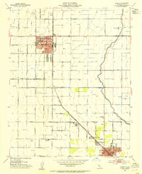
1953 Map of Wasco
USGS Topo · Published 1954About this map
Wasco serves as a central hub for the agricultural landscape of Kern County in this mid-century survey, defined by its rectilinear grid and burgeoning infrastructure. The city center is anchored by City Hall, the Union High School, and Thomas Jefferson Sch, while the Wasco Airport marks the northern edge of development. South of the main town site, smaller nodes like Myricks Corner, North Shafter, and the northern portion of Shafter show the steady southward expansion of settlement along the Atchison Topeka and Santa Fe railroad line.
Find a feature on this map
57 named features on this map. Tap any name to fly to it.
Don’t see what you’re looking for? This feature index may not catch every label — zoom into the map to look around manually.
Map Details
Editions of this 1953 Wasco Map
Other maps of this area

1910 · Buena Vista Lake
USGS Topo · 1:125,000

1912 · Buena Vista Lake
USGS Topo · 1:125,000

1927 · McFarland
USGS Topo · 1:31,680

1930 · McFarland
USGS Topo · 1:31,680

1930 · Leonards
USGS Topo · 1:31,680

1930 · Hamlin School
USGS Topo · 1:31,680

1930 · Wasco
USGS Topo · 1:31,680

1930 · Pond
USGS Topo · 1:31,680

1930 · Famoso
USGS Topo · 1:31,680

1930 · Rosedale
USGS Topo · 1:31,680