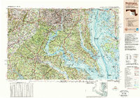
1989 Map of Washington
USGS Topo · Published 1989About this map
The Potomac River serves as the central artery of this regional study, dividing the burgeoning suburbs of Virginia and Maryland as they appeared in the late 1980s. This survey illustrates the dense urban corridor from Washington and Alexandria down through the Northern Neck, where historical sites like Mount Vernon and Stratford Hall sit alongside major military installations such as Quantico Marine Corps Base and the Dahlgren Naval Surface Weapons Center.
Find a feature on this map
238 named features on this map. Tap any name to fly to it.
Don’t see what you’re looking for? This feature index may not catch every label — zoom into the map to look around manually.
Map Details
Editions of this 1989 Washington Map
This is the sole edition of this map. No revisions or reprints were ever made.
Other maps of this area

1884 · Harpers Ferry
USGS Topo · 1:125,000

1887 · Spottsylvania
USGS Topo · 1:125,000

1889 · Fredericksburg
USGS Topo · 1:125,000

1890 · Goochland
USGS Topo · 1:125,000

1890 · Mt. Vernon
USGS Topo · 1:125,000

1891 · Harpers Ferry
USGS Topo · 1:125,000

1891 · Palmyra
USGS Topo · 1:125,000

1891 · Mt. Vernon
USGS Topo · 1:125,000

1892 · Leonardtown
USGS Topo · 1:62,500

1892 · Laurel
USGS Topo · 1:62,500