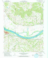
1972 Map of Washington East
USGS Topo · Published 1973About this map
The Missouri River bisects this 1972 survey, creating a dramatic geographic divide between the hill country of Femme Osage to the north and the industrial riverfront of Washington. On the southern bank, the city of Washington thrives as a transportation hub where the Missouri Pacific railroad parallels the riverbank, passing by South Point Sch and several large quarries. Across the water, the expansive floodplain of Hancock Bottom sits beneath the Missouri-Kansas-Texas rail line, which services the smaller settlements of Dutzow and Augusta.
Find a feature on this map
37 named features on this map. Tap any name to fly to it.
Don’t see what you’re looking for? This feature index may not catch every label — zoom into the map to look around manually.
Map Details
Editions of this 1972 Washington East Map
This is the sole edition of this map. No revisions or reprints were ever made.
Other maps of this area

1890 · Hermann
USGS Topo · 1:125,000

1901 · De Soto
USGS Topo · 1:125,000

1903 · O'Fallon
USGS Topo · 1:125,000

1903 · Sullivan
USGS Topo · 1:125,000

1946 · Union
USGS Topo · 1:62,500

1947 · St. Clair
USGS Topo · 1:62,500

1948 · Union
USGS Topo · 1:62,500

1948 · Washington
USGS Topo · 1:62,500

1948 · Augusta
USGS Topo · 1:62,500

1949 · Saint Louis
USGS Topo · 1:250,000