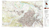
1985 Map of St Louis
USGS Topo · Published 1988About this map
The confluence of the Mississippi River, Missouri River, and Illinois River dominates this mid-1980s landscape, illustrating the massive industrial and urban footprint of the St. Louis metropolitan area. Dense residential and commercial development radiates from the riverfront through St Louis and St Charles, supported by a complex web of transport including the Terminal RR Association and major hubs like Lambert-St Louis International Airport. To the west, the urban grid gives way to managed conservation lands such as the August A Busch Memorial Wildlife Area and Weldon Spring State Wildlife Area. Cultural and historic markers are prominent throughout, from the ancient heights of Cahokia Mounds State Park on the Illinois side to the Jefferson Barracks Nat Cem and the sprawling grounds of Washington University.
Find a feature on this map
305 named features on this map. Tap any name to fly to it.
Don’t see what you’re looking for? This feature index may not catch every label — zoom into the map to look around manually.
Map Details
Editions of this 1985 St Louis Map
3 editions found

Other maps of this area

1888 · St. Louis
USGS Topo · 1:62,500

1890 · Louisiana
USGS Topo · 1:125,000

1890 · Hermann
USGS Topo · 1:125,000

1901 · De Soto
USGS Topo · 1:125,000

1903 · O'Fallon
USGS Topo · 1:125,000

1903 · Sullivan
USGS Topo · 1:125,000

1907 · Belleville
USGS Topo · 1:62,500

1910 · Waterloo
USGS Topo · 1:62,500

1912 · New Athens
USGS Topo · 1:62,500

1912 · Kimmswick
USGS Topo · 1:62,500