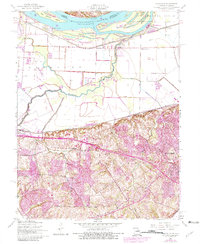
1954 Map of Kampville
USGS Topo · Published 1982About this map
The Mississippi River dominates the northern landscape of this Missouri quadrangle, punctuated by numerous islands like Two Branch Island and Dardenne Island. In the mid-20th century, the Golden Eagle Ferry provided a vital river crossing, connecting the fertile bottomlands of St. Charles County to the neighboring Illinois shoreline. The river economy is evident through several river-access points such as McCann Landing and Fruitland Landing.
Find a feature on this map
36 named features on this map. Tap any name to fly to it.
Don’t see what you’re looking for? This feature index may not catch every label — zoom into the map to look around manually.
Map Details
Editions of this 1954 Kampville Map
4 editions found
Other maps of this area

1903 · O'Fallon
USGS Topo · 1:125,000

1924 · Robertson
USGS Topo · 1:24,000

1927 · St. Charles
USGS Topo · 1:62,500

1931 · Brussels
USGS Topo · 1:62,500

1932 · Manchester NE
USGS Topo · 1:24,000

1933 · Creve Coeur
USGS Topo · 1:24,000

1933 · Saint Charles
USGS Topo · 1:62,500

1937 · Weldon Spring
USGS Topo · 1:24,000

1939 · Brussels
USGS Topo · 1:62,500

1940 · Weldon Spring
USGS Topo · 1:24,000