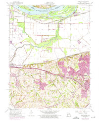
1954 Map of Kampville
USGS Topo · Published 1975About this map
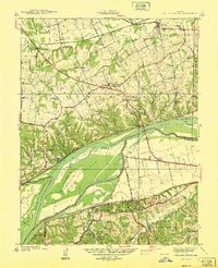
The Mississippi River defines the northern edge of this landscape, carving out a complex of low-lying islands including Two Branch Island, Apple Island, and Dardenne Island. To the south, the terrain transitions from the alluvial floodplain of the Portage Des Sioux toward the rising bluffs of St Charles. The area is a mosaic of mid-century infrastructure and older river settlements, where the Burlington Northern and Norfolk And Western railroads parallel the river's course. Local life is anchored by landmarks like Kampville Sch and Friedens Ch, while the riverbank reveals historical access points such as McCann Landing and Fruitland Landing. Revisions in the mid-1970s illustrate the suburban expansion around St Peters and the city of St. Charles, contrasting the established agricultural levees with new residential footprints and features like the local Drive-in Theater.
Find a feature on this map
45 named features on this map. Tap any name to fly to it.
Don’t see what you’re looking for? This feature index may not catch every label — zoom into the map to look around manually.
Map Details
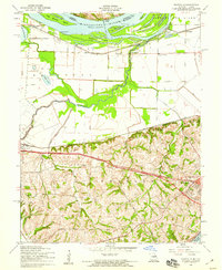
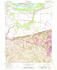
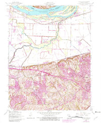
Editions of this 1954 Kampville Map
4 editions found
Other maps of this area

1903 · O'Fallon
USGS Topo · 1:125,000

1924 · Robertson
USGS Topo · 1:24,000

1927 · St. Charles
USGS Topo · 1:62,500

1931 · Brussels
USGS Topo · 1:62,500

1932 · Manchester NE
USGS Topo · 1:24,000

1933 · Creve Coeur
USGS Topo · 1:24,000

1933 · Saint Charles
USGS Topo · 1:62,500

1937 · Weldon Spring
USGS Topo · 1:24,000

1939 · Brussels
USGS Topo · 1:62,500
1940 · Weldon Spring
USGS Topo · 1:24,000