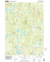
1998 Map of Washington
USGS Topo · Published 2002About this map
Pillsbury State Park dominates the northern reaches of this New Hampshire landscape, preserving a dense network of water bodies including May Pond, Mill Pond, and North Pond. The village of Washington serves as a central hub, where the Center Sch and local cemeteries anchor the community near the shores of Millen Lake. This late-twentieth-century survey illustrates the region's enduring character as a recreational and conservation corridor, highlighted by the Monadnock-Sunapee Greenway Trail and the Pillsbury-Sunapee Corridor trekking through the high ground of Lowell Mountain. To the east, the settlement of East Washington sits along Beards Brook, while the southern area transitions into Windsor and the expansive waters of Highland Lake, reflecting the traditional New England pattern of small-town centers integrated with significant protected woodlands.
Find a feature on this map
64 named features on this map. Tap any name to fly to it.
Don’t see what you’re looking for? This feature index may not catch every label — zoom into the map to look around manually.
Map Details
Editions of this 1998 Washington Map
This is the sole edition of this map. No revisions or reprints were ever made.
Other maps of this area

1902 · Sunapee
USGS Topo · 1:62,500

1905 · Sunapee
USGS Topo · 1:62,500

1907 · Sunapee
USGS Topo · 1:62,500

1926 · Hillsboro
USGS Topo · 1:62,500

1928 · Mount Kearsarge
USGS Topo · 1:62,500

1929 · Hillsboro
USGS Topo · 1:62,500

1930 · Lovewell Mountain
USGS Topo · 1:62,500

1931 · Mount Kearsarge
USGS Topo · 1:62,500

1942 · Lovewell Mountain
USGS Topo · 1:62,500

1949 · Portland
USGS Topo · 1:250,000