1986 Map of Washington West
USGS Topo · Published 1986About this map
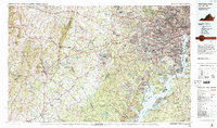
The Potomac River corridor anchors this mid-1980s landscape, serving as the border between the expanding suburban developments of Northern Virginia and the historic urban core of Washington. This map illustrates the dense concentration of federal power and military infrastructure, including the Pentagon, Fort Belvoir Military Reservation, and the Vint Hill Farms Station Military Reservation. To the west, the urban density of Alexandria and Arlington gives way to the planned communities of Reston and the academic grounds of George Mason University in Fairfax.
Find a feature on this map
116 named features on this map. Tap any name to fly to it.
Don’t see what you’re looking for? This feature index may not catch every label — zoom into the map to look around manually.
Map Details
Editions of this 1986 Washington West Map
2 editions found

Other maps of this area

1884 · Harpers Ferry
USGS Topo · 1:125,000

1887 · Spottsylvania
USGS Topo · 1:125,000

1889 · Fredericksburg
USGS Topo · 1:125,000

1890 · Mt. Vernon
USGS Topo · 1:125,000

1891 · Harpers Ferry
USGS Topo · 1:125,000

1891 · Mt. Vernon
USGS Topo · 1:125,000

1892 · Laurel
USGS Topo · 1:62,500

1892 · Fredericksburg
USGS Topo · 1:125,000

1892 · Spottsylvania
USGS Topo · 1:125,000

1892 · Brandywine
USGS Topo · 1:62,500