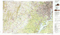
1986 Map of Washington West
USGS Topo · Published 1986About this map
The Potomac River corridor anchors this mid-1980s look at the expanding suburbs and preserved landscapes of Northern Virginia and Maryland. From the urban core of Washington, Alexandria, and the Pentagon, development reaches westward through Fairfax and Reston toward the growing aviation hub at Dulles International Airport. The map highlights significant federal and military tracts that have shaped regional land use, including the Fort Belvoir Military Reservation and the Marine Corps Development and Education Command (Quantico).
Find a feature on this map
77 named features on this map. Tap any name to fly to it.
Don’t see what you’re looking for? This feature index may not catch every label — zoom into the map to look around manually.
Map Details
Editions of this 1986 Washington West Map
2 editions found
Other maps of this area

1884 · Harpers Ferry
USGS Topo · 1:125,000

1887 · Spottsylvania
USGS Topo · 1:125,000

1889 · Fredericksburg
USGS Topo · 1:125,000

1890 · Mt. Vernon
USGS Topo · 1:125,000

1891 · Harpers Ferry
USGS Topo · 1:125,000

1891 · Mt. Vernon
USGS Topo · 1:125,000

1892 · Laurel
USGS Topo · 1:62,500

1892 · Fredericksburg
USGS Topo · 1:125,000

1892 · Spottsylvania
USGS Topo · 1:125,000

1892 · Brandywine
USGS Topo · 1:62,500