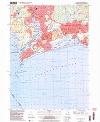
2001 Map of Watch Hill
USGS Topo · Published 2003About this map
The Pawcatuck River serves as the dividing line between Connecticut and Rhode Island, connecting the industrial and residential centers of Pawcatuck and Westerly. Along the river’s southern reaches, the landscape shifts from developed town centers to the maritime communities of Avondale and Watch Hill. The coastline is defined by distinctive barrier features like Napatree Beach and the protective arm of Watch Hill Pt, home to the Watch Hill Lighthouse. This coastal environment is characterized by a series of saltwater ponds, including Winnapaug Pond and Maschaug Pond, which separate the inland estates and golf courses from the Atlantic surf. To the east, Misquamicut and Weekapaug highlight the region’s long history as a premier summer destination, while inland cemeteries like River Bend Cem and St Sebastian Cem provide vital links for those tracing the generations that built these border towns.
Find a feature on this map
82 named features on this map. Tap any name to fly to it.
Don’t see what you’re looking for? This feature index may not catch every label — zoom into the map to look around manually.
Map Details
Editions of this 2001 Watch Hill Map
This is the sole edition of this map. No revisions or reprints were ever made.
Other maps of this area

1889 · Stonington
USGS Topo · 1:62,500

1889 · Charlestown
USGS Topo · 1:62,500

1889 · Block Island
USGS Topo · 1:62,500

1893 · Stonington
USGS Topo · 1:62,500

1894 · Block Island
USGS Topo · 1:62,500

1899 · Block Island
USGS Topo · 1:62,500

1904 · Montauk
USGS Topo · 1:62,500

1919 · Charlestown
USGS Topo · 1:62,500

1921 · Charlestown
USGS Topo · 1:62,500

1921 · Stonington
USGS Topo · 1:62,500