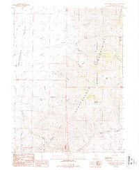
1987 Map of Water Pipe Canyon
USGS Topo · Published 1987About this map
The Independence Mountains dominate this high-desert landscape in northeastern Nevada, where the ridgeline separates the Independence Valley to the west from the drainage basins of the Humboldt National Forest to the east. The terrain is defined by a dense network of steep drainages, including Mill Creek, Burns Creek, and Rocky Canyon, which cut through the uplift towards the valley floor. Evidence of historic resource extraction and seasonal land use is scattered throughout the canyons, including a Mill site and several Adit markers, particularly near the headwaters of Water Pipe Canyon.
Find a feature on this map
28 named features on this map. Tap any name to fly to it.
Don’t see what you’re looking for? This feature index may not catch every label — zoom into the map to look around manually.
Map Details
Editions of this 1987 Water Pipe Canyon Map
This is the sole edition of this map. No revisions or reprints were ever made.
Other maps of this area

1955 · McDermitt
USGS Topo · 1:250,000

1955 · Wells
USGS Topo · 1:250,000

1956 · Tuscarora
USGS Topo · 1:62,500

1958 · Wells
USGS Topo · 1:250,000

1959 · McDermitt
USGS Topo · 1:250,000

1961 · Wells
USGS Topo · 1:250,000

1970 · Lake Mountain
USGS Topo · 1:24,000

1970 · Stampede Ranch
USGS Topo · 1:24,000

1971 · Mahala Creek West
USGS Topo · 1:24,000

1971 · California Mtn.
USGS Topo · 1:24,000