
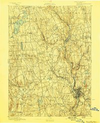
1893 Map of Waterbury
USGS Topo · Published 1893About this map
The Naugatuck River valley serves as the industrial and transportation corridor of this late-nineteenth-century landscape, anchored by the dense urban center of Waterbury. The Naugatuck R. R. follows the river's winding path through the hills, connecting specialized manufacturing settlements like Thomaston, Waterville, and Oakville. This era reveals a transition between the established river-mill economy and a more complex rail network, including the New York and New England R. R. traversing the southern portion of the sheet. To the west, the terrain rises toward Bantam Lake, where smaller agrarian and residential villages such as Morris and Bethlehem provide a distinct contrast to the busy river valley. Numerous named heights like Breakneck Hill and Town Plot Hill underscore the difficult topography that dictated the placement of roads and rails during this period of New England's expansion.
Find a feature on this map
96 named features on this map. Tap any name to fly to it.
Don’t see what you’re looking for? This feature index may not catch every label — zoom into the map to look around manually.
Map Details
Editions of this 1893 Waterbury Map
2 editions found
Other maps of this area

1889 · Derby
USGS Topo · 1:62,500

1891 · Derby
USGS Topo · 1:62,500

1892 · Winsted
USGS Topo · 1:62,500

1892 · New Haven
USGS Topo · 1:62,500

1892 · Danbury
USGS Topo · 1:62,500

1892 · Cornwall
USGS Topo · 1:62,500

1892 · New Milford
USGS Topo · 1:62,500

1892 · Meriden
USGS Topo · 1:62,500

1892 · Granby
USGS Topo · 1:62,500

1893 · New Milford
USGS Topo · 1:62,500