
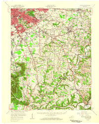
1951 Map of Waterford
USGS Topo · Published 1951About this map
Plum Creek winds southward through a deeply dissected landscape in this mid-century survey of the Spencer and Bullitt County borders. The settlement of Waterford serves as a central hub where the creek meets the wide, meandering Salt River. The map captures a predominantly rural agricultural period, characterized by dispersed farmsteads and a network of secondary roads such as Dawson Mill Road and the Frankfort Pike. Local social life is anchored by community landmarks like Carrithers Chapel, Kings Ch, and the Locust Grove Sch. This 1951 edition highlights the intricate drainage patterns of the area, including Feather Bed Hollow and numerous runs, which dictated the placement of small hamlets like Whitfield and Wilsonville. The survey provides an essential view of these rural Kentucky communities just after the post-war field checks of 1950.
Find a feature on this map
28 named features on this map. Tap any name to fly to it.
Don’t see what you’re looking for? This feature index may not catch every label — zoom into the map to look around manually.
Map Details
Editions of this 1951 Waterford Map
This is the sole edition of this map. No revisions or reprints were ever made.
Other maps of this area

1907 · Louisville
USGS Topo · 1:62,500

1929 · Taylorsville
USGS Topo · 1:62,500

1949 · Samuels
USGS Topo · 1:24,000

1949 · Shepherdsville
USGS Topo · 1:62,500

1951 · Jeffersontown
USGS Topo · 1:24,000

1951 · Fisherville
USGS Topo · 1:24,000

1951 · Mount Washington
USGS Topo · 1:24,000
1951 · Louisville
USGS Topo · 1:62,500

1953 · Bloomfield
USGS Topo · 1:24,000

1953 · Fairfield
USGS Topo · 1:24,000