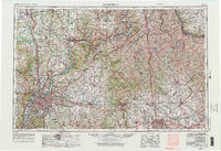
1951 Map of Louisville
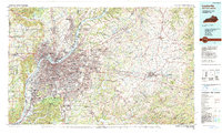
USGS Topo · Published 1959About this map
The Louisville metropolitan area undergoes significant post-war expansion in this early 1950s survey, showing the transition from dense urban blocks to suburban developments like Audubon Park and Okolona. Aviation infrastructure is a dominant feature, anchored by Bowman Field and the newer Standiford Field. The landscape south of the city is defined by the Louisville and Nashville RR and Southern RR corridors, which supported a growing industrial base including local Kilns and a Fish hatchery.
Find a feature on this map
152 named features on this map. Tap any name to fly to it.
Don’t see what you’re looking for? This feature index may not catch every label — zoom into the map to look around manually.
Map Details
Editions of this 1951 Louisville Map
This is the sole edition of this map. No revisions or reprints were ever made.
Historical Maps of Louisville Through Time
5 maps found