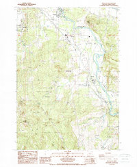
1988 Map of Waterloo
USGS Topo · Published 1988About this map
The South Santiam River winds through this mid-valley landscape, punctuated by several historic riverside settlements including Waterloo and Fairview. To the west, the town of Sodaville sits at the base of the upland terrain, while the heights of Scott Mountain and Marks Ridge rise to the south and east. This late 1980s provisional survey shows a mix of small-town development and rural industry, with numerous quarries and a Borrow Pit scattered near the riverbanks. Local community hubs like Mountain Home, Liberty, and Greenville serve as navigational anchors in a region defined by agricultural fields and the wooded slopes surrounding Binegar Butte. The map also captures recreation and utility features, ranging from the Picnic Area at the river's bend to a Golf Course and a prominent Radio Tower in the higher elevations.
Find a feature on this map
25 named features on this map. Tap any name to fly to it.
Don’t see what you’re looking for? This feature index may not catch every label — zoom into the map to look around manually.
Map Details
Editions of this 1988 Waterloo Map
This is the sole edition of this map. No revisions or reprints were ever made.
Other maps of this area

1911 · Brownsville
USGS Topo · 1:31,680

1911 · Lebanon
USGS Topo · 1:31,680

1921 · Brownsville
USGS Topo · 1:62,500

1921 · Lebanon
USGS Topo · 1:62,500

1922 · Lebanon
USGS Topo · 1:48,000

1924 · Lebanon
USGS Topo · 1:62,500

1940 · Lebanon
USGS Topo · 1:62,500

1944 · Lebanon
USGS Topo · 1:62,500

1950 · Brownsville
USGS Topo · 1:62,500

1951 · Sweet Home
USGS Topo · 1:62,500