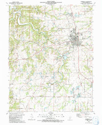
1991 Map of Waterloo
USGS Topo · Published 1991About this map
Waterloo serves as the primary hub of this Monroe County landscape, showing the town's layout just before the turn of the millennium. The survey details a transition from the structured street grid of the town center to the outlying agrarian and wooded terrain. Significant local heritage is preserved in the documentation of several country schools and churches, such as the Old Rock Sch and Holy Cross Ch. The map also captures the path of an Old RR Grade, tracing a vanished transportation corridor that once linked these rural communities.
Find a feature on this map
36 named features on this map. Tap any name to fly to it.
Don’t see what you’re looking for? This feature index may not catch every label — zoom into the map to look around manually.
Map Details
Editions of this 1991 Waterloo Map
This is the sole edition of this map. No revisions or reprints were ever made.
Other maps of this area

1910 · Waterloo
USGS Topo · 1:62,500

1912 · Kimmswick
USGS Topo · 1:62,500

1913 · Waterloo
USGS Topo · 1:62,500

1915 · Renault
USGS Topo · 1:62,500

1915 · Crystal City
USGS Topo · 1:62,500

1916 · Kimmswick
USGS Topo · 1:62,500

1940 · Renault
USGS Topo · 1:62,500

1948 · Kimmswick
USGS Topo · 1:62,500

1949 · Saint Louis
USGS Topo · 1:250,000

1949 · Crystal City
USGS Topo · 1:62,500