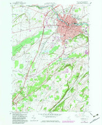
1959 Map of Watertown
USGS Topo · Published 1983About this map
The Black River carves through the heart of this Jefferson County landscape, serving as the industrial and geographic anchor for Watertown. This 1959 survey, updated with purple photorevisions from 1981, reveals the city's complex urban fabric, from the residential clusters around Starbuck Sch and State St Sch to the institutional grounds of the County Fairground and Mercy Hosp. The presence of Sewalls Island and Diamond Island within the river channel highlights the historical importance of the waterway to local power and industry. Beyond the city limits, the terrain transitions into the agricultural and wooded expanses of Dry Hill and Boynton Hill. Evidence of early settlement patterns persists in the outskirts at Fields Settlement and Talcott Corners, while numerous burial grounds like Arsenal St Cem and Graves Hill Cem provide vital links for local genealogical research.
Find a feature on this map
69 named features on this map. Tap any name to fly to it.
Don’t see what you’re looking for? This feature index may not catch every label — zoom into the map to look around manually.
Map Details
Editions of this 1959 Watertown Map
3 editions found
Other maps of this area

1893 · Sackets Harbor
USGS Topo · 1:62,500

1895 · Sacketts Harbor
USGS Topo · 1:62,500

1895 · Watertown
USGS Topo · 1:62,500

1898 · Watertown
USGS Topo · 1:62,500

1900 · Clayton
USGS Topo · 1:62,500

1903 · Clayton
USGS Topo · 1:62,500

1903 · Theresa
USGS Topo · 1:62,500

1908 · Watertown
USGS Topo · 1:62,500

1909 · Watertown
USGS Topo · 1:62,500
1943 · Sackets Harbor
USGS Topo · 1:31,680