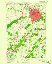
1959 Map of Watertown
USGS Topo · Published 1961About this map
The Black River defines the industrial and civic heart of this Jefferson County hub, where the New York Central railroad tracks converge near the bustling downtown. The 1950s urban landscape is densely packed with neighborhood schools like Starbuck Sch and Meade St Sch, alongside specialized institutions including the County Childrens Home and the County Hospital. Beyond the city limits, the terrain transitions into a mosaic of rural hamlets and agricultural crossroads such as Fields Settlement and Talcott Corners. Geologists and local historians can trace the steep drop of Talcott Falls in the south, while several large burial grounds like Brookside Cemetery and Glenwood Cemetery provide significant genealogical touchpoints for the region. The map also highlights the era's mid-century leisure and infrastructure, from the Watertown Golf Club and Drive-in Theater to the extensive Pipeline corridors cutting across the township.
Find a feature on this map
60 named features on this map. Tap any name to fly to it.
Don’t see what you’re looking for? This feature index may not catch every label — zoom into the map to look around manually.
Map Details
Editions of this 1959 Watertown Map
3 editions found
Other maps of this area

1893 · Sackets Harbor
USGS Topo · 1:62,500

1895 · Sacketts Harbor
USGS Topo · 1:62,500

1895 · Watertown
USGS Topo · 1:62,500

1898 · Watertown
USGS Topo · 1:62,500

1900 · Clayton
USGS Topo · 1:62,500

1903 · Clayton
USGS Topo · 1:62,500

1903 · Theresa
USGS Topo · 1:62,500

1908 · Watertown
USGS Topo · 1:62,500

1909 · Watertown
USGS Topo · 1:62,500
1943 · Sackets Harbor
USGS Topo · 1:31,680