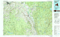
1985 Map of Watertown
USGS Topo · Published 1994About this map
Watertown and its surroundings serve as the industrial and transit hub of this North Country landscape, where the Black River powers communities like Carthage, Lowville, and West Carthage. The transition from the agricultural plains of Jefferson and Lewis Counties to the heavily forested Adirondack Park is starkly defined. In the east, the vast Stillwater Reservoir and Big Moose Lake sit deep within the wilderness, while the southwest is dominated by the Tug Hill plateau, a region noted for its heavy snowfall and relative isolation.
Find a feature on this map
128 named features on this map. Tap any name to fly to it.
Don’t see what you’re looking for? This feature index may not catch every label — zoom into the map to look around manually.
Map Details
Editions of this 1985 Watertown Map
2 editions found
Other maps of this area

1893 · Sackets Harbor
USGS Topo · 1:62,500

1895 · Sacketts Harbor
USGS Topo · 1:62,500

1895 · Pulaski
USGS Topo · 1:62,500

1895 · Watertown
USGS Topo · 1:62,500

1897 · Remsen
USGS Topo · 1:62,500

1898 · Watertown
USGS Topo · 1:62,500

1900 · Remsen
USGS Topo · 1:62,500

1900 · Wilmurt
USGS Topo · 1:62,500

1900 · Clayton
USGS Topo · 1:62,500

1901 · Old Forge
USGS Topo · 1:62,500