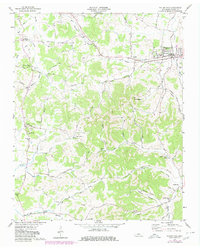
1958 Map of Watertown
USGS Topo · Published 1980About this map
Watertown anchors this landscape of Wilson County at a time when the Louisville and Nashville railroad and the Sparta Pike served as the primary conduits for commerce and travel through the region. The map reveals a dense network of rural settlements and family landmarks, from the crossroads at Doaks Crossroads to the cluster of homes at Sherrilltown. This mid-century survey captures a transition in Tennessee's agricultural heartland, where local social life centered on institutions like Norene Sch and churches such as Fall Creek Ch and Ramah Ch.
Find a feature on this map
58 named features on this map. Tap any name to fly to it.
Don’t see what you’re looking for? This feature index may not catch every label — zoom into the map to look around manually.
Map Details
Editions of this 1958 Watertown Map
2 editions found

Other maps of this area

1908 · Woodbury
USGS Topo · 1:62,500

1916 · Murfreesboro
USGS Topo · 1:62,500

1942 · Statesville
USGS Topo · 1:100,000

1942 · Lebanon
USGS Topo · 1:100,000

1951 · Lebanon
USGS Topo · 1:24,000

1956 · Vine
USGS Topo · 1:24,000

1956 · Columbia
USGS Topo · 1:250,000

1956 · Nashville
USGS Topo · 1:250,000
1957 · Lascassas
USGS Topo · 1:24,000

1958 · New Middleton
USGS Topo · 1:24,000