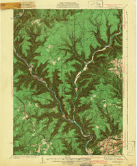
1943 Map of Waterville
USGS Topo · Published 1943About this map
Pine Creek carves a deep, winding gorge through this 1943 survey of Lycoming and Clinton counties, dictating the placement of early mountain settlements and transport routes. Hamlets like Waterville, Jersey Mills, and Cammal cling to the narrow valley floors, while the surrounding high ridges—such as Flatiron Ridge and Chestnut Ridge—remain largely undeveloped. The presence of a CCC Camp and a Fire Tower suggests the importance of forest management and fire observation during this era. Family-history researchers can locate specific burial sites at the Okome Cem, Carsontown Cem, and Bluestone Cem, while the Springer Sch and local churches like Caldwell Ch reveal the scattered social centers of these remote upland communities before mid-century modernization.
Find a feature on this map
127 named features on this map. Tap any name to fly to it.
Don’t see what you’re looking for? This feature index may not catch every label — zoom into the map to look around manually.
Map Details
Editions of this 1943 Waterville Map
3 editions found

Other maps of this area

1921 · Howard
USGS Topo · 1:48,000

1921 · Williamsport
USGS Topo · 1:48,000

1921 · Trout Run
USGS Topo · 1:62,500

1921 · Lock Haven
USGS Topo · 1:62,500

1923 · Howard
USGS Topo · 1:62,500

1923 · Lock Haven
USGS Topo · 1:62,500

1923 · Trout Run
USGS Topo · 1:62,500

1923 · Williamsport
USGS Topo · 1:62,500

1925 · Blossburg
USGS Topo · 1:62,500

1927 · Blossburg
USGS Topo · 1:62,500
Featured Places
- Gallagher Township, PA
- Brookside, Cogan House Township
- Mifflin Township, PA
- Cogan House Township, PA
- Carsontown, Pine Township