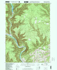
1994 Map of Waterville
USGS Topo · Published 1999About this map
Waterville serves as the focal point for this survey of the Lycoming County backcountry, situated where Little Pine Creek meets the larger Pine Creek. The landscape is dominated by the steep drainages of Tiadaghton State Forest and the recreational development within Little Pine State Park, including the Little Pine Dam and Little Pine Picnic Area. Local history is preserved in the naming of remote hollows and high points, such as Henson Ridge and Little Round Top. Evidence of rural community life appears at Mt Pleasant Ch and its neighboring cemetery in the southern portion of the map. The terrain is marked by an extensive network of waterways like Ramsey Run and English Run, which have carved deep into Houselander Mountain and Puterbaugh Mountain, illustrating the region's long-standing reliance on its river-cut geography for both transport and industry.
Find a feature on this map
57 named features on this map. Tap any name to fly to it.
Don’t see what you’re looking for? This feature index may not catch every label — zoom into the map to look around manually.
Map Details
Editions of this 1994 Waterville Map
This is the sole edition of this map. No revisions or reprints were ever made.
Other maps of this area

1921 · Williamsport
USGS Topo · 1:48,000

1921 · Trout Run
USGS Topo · 1:62,500

1921 · Lock Haven
USGS Topo · 1:62,500

1923 · Lock Haven
USGS Topo · 1:62,500

1923 · Trout Run
USGS Topo · 1:62,500

1923 · Williamsport
USGS Topo · 1:62,500

1935 · Waterville
USGS Topo · 1:24,000

1937 · Waterville
USGS Topo · 1:48,000

1943 · Waterville
USGS Topo · 1:62,500

1944 · Trout Run
USGS Topo · 1:62,500
Featured Places
- Mifflin Township, PA
- Cogan House Township, PA
- Watson Township, PA
- Ramsey, Cummings Township
- English Mills, Cummings Township