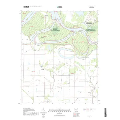
2020 Map of Watson
USGS Topo · Published 2020About this map
Watson and the small settlements of Pea Ridge and Red Fork anchor this landscape where the Arkansas River winds through the lowlands of Desha and Arkansas counties. The river's historical shifts are evident in the complex network of oxbow lakes and drainages, including Belcoe Lake, Red Fork Lake, and Menard Bayou. To the north, the Arkansas Post National Memorial marks a site of significant early regional importance, while much of the river corridor is preserved within the Dale Bumpers White River National Wildlife Refuge. Numerous family and community burial grounds, such as Jones Cem, Irby Cem, and Porter Cem, are scattered across the agricultural plains and ridges, providing essential data points for genealogical research. The presence of the Levee and the Great River Rd underscores the ongoing relationship between human infrastructure and the powerful river systems that have shaped this delta environment over centuries.
Find a feature on this map
54 named features on this map. Tap any name to fly to it.
Don’t see what you’re looking for? This feature index may not catch every label — zoom into the map to look around manually.
Map Details
Editions of this 2020 Watson Map
This is the sole edition of this map. No revisions or reprints were ever made.
Other maps of this area

1935 · Red Fork
USGS Topo · 1:62,500

1935 · Gillett
USGS Topo · 1:62,500

1939 · Henrico
USGS Topo · 1:62,500

1939 · Big Island
USGS Topo · 1:62,500

1948 · Helena
USGS Topo · 1:250,000

1950 · Helena
USGS Topo · 1:250,000

1953 · Greenwood
USGS Topo · 1:250,000

1954 · Henrico
USGS Topo · 1:62,500

1955 · Helena
USGS Topo · 1:250,000

1956 · Greenwood
USGS Topo · 1:250,000