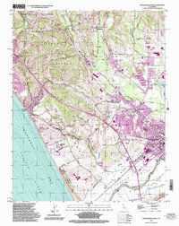
1995 Map of Watsonville West
USGS Topo · Published 1998About this map
Watsonville serves as the focal point of this coastal survey, where the Pajaro Valley's agricultural heritage meets the complex hydrologic network of Watsonville Slough, Struve Slough, and Harkins Slough. The landscape transition is evident between the residential expansion around Freedom and the protected habitats of the Santa Cruz County Long-toed Salamander Ecological Reserve. Along the Monterey Bay shoreline, the map details the recreational and educational assets at Manresa State Beach and the Monterey Bay Academy. To the north, the inland terrain rises into the foothills near Corralitos, where the Corralitos Union Sch and local Gravel Pits reflect a community defined by both natural resource extraction and rural education. The presence of the Southern Pacific railroad corridor through Ellicott and Pajaro underscores the historical importance of rail in moving the region's produce.
Find a feature on this map
76 named features on this map. Tap any name to fly to it.
Don’t see what you’re looking for? This feature index may not catch every label — zoom into the map to look around manually.
Map Details
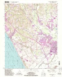
Editions of this 1995 Watsonville West Map
2 editions found
Other maps of this area

1912 · Capitola
USGS Topo · 1:62,500

1914 · Capitola
USGS Topo · 1:62,500

1915 · San Juan Bautista
USGS Topo · 1:48,000

1916 · New Almaden
USGS Topo · 1:48,000

1917 · Morgan Hill
USGS Topo · 1:62,500

1917 · San Juan Bautista
USGS Topo · 1:62,500

1919 · New Almaden
USGS Topo · 1:62,500

1939 · Morgan Hill
USGS Topo · 1:62,500

1939 · San Juan Bautista
USGS Topo · 1:62,500

1940 · San Juan Bautista
USGS Topo · 1:62,500