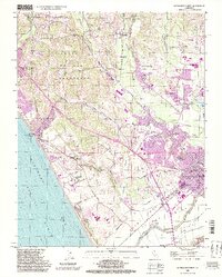
1995 Map of Watsonville West
USGS Topo · Published 1998About this map
Watsonville and its surrounding agricultural valleys are the focal point of this coastal survey, where the Pajaro River drainage meets Monterey Bay. The landscape is defined by an intricate network of wetlands, including Harkins Slough, Struve Slough, and Watsonville Slough, which weave through the lowlands south of the city. To the north, the terrain transitions into the foothills of the Laguna de las Calabasas and Pleasant Valley, where small settlements like Corralitos and Rio Del Mar are established. Local history is well-preserved through labels for the Day Valley Cem and several educational institutions such as Corralitos Union Sch and Monte Vista Christian Sch. The presence of the Watsonville Municipal Airport and the Watsonville State Wildlife Area highlights the mid-century balance between regional infrastructure and the conservation of the Pajaro Valley’s distinctive slough system.
Find a feature on this map
57 named features on this map. Tap any name to fly to it.
Don’t see what you’re looking for? This feature index may not catch every label — zoom into the map to look around manually.
Map Details
Editions of this 1995 Watsonville West Map
2 editions found
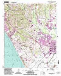
Other maps of this area

1912 · Capitola
USGS Topo · 1:62,500

1914 · Capitola
USGS Topo · 1:62,500

1915 · San Juan Bautista
USGS Topo · 1:48,000

1916 · New Almaden
USGS Topo · 1:48,000

1917 · Morgan Hill
USGS Topo · 1:62,500

1917 · San Juan Bautista
USGS Topo · 1:62,500

1919 · New Almaden
USGS Topo · 1:62,500

1939 · Morgan Hill
USGS Topo · 1:62,500

1939 · San Juan Bautista
USGS Topo · 1:62,500

1940 · San Juan Bautista
USGS Topo · 1:62,500