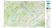
1981 Map of Watts Bar Lake
USGS Topo · Published 1984About this map
Watts Bar Lake and the winding Tennessee River dominate this regional landscape during a period of significant industrial and energy development. The map documents the footprint of the Tennessee Valley Authority's infrastructure, from the Watts Bar Dam to the Watts Bar Nuclear Plant, then under construction, and the proposed Clinch River Breeder Reactor. This era saw the recent creation of Tellico Lake and the established waters of Fort Loudoun Lake, reflecting the total transformation of the river valley into a managed reservoir system.
Find a feature on this map
97 named features on this map. Tap any name to fly to it.
Don’t see what you’re looking for? This feature index may not catch every label — zoom into the map to look around manually.
Map Details
Editions of this 1981 Watts Bar Lake Map
2 editions found
Other maps of this area

1886 · Cleveland
USGS Topo · 1:125,000

1886 · Knoxville
USGS Topo · 1:125,000

1887 · Kingston
USGS Topo · 1:125,000

1888 · Chattanooga
USGS Topo · 1:125,000

1891 · Kingston
USGS Topo · 1:125,000

1892 · Pikeville
USGS Topo · 1:125,000

1892 · Cleveland
USGS Topo · 1:125,000

1892 · Knoxville
USGS Topo · 1:125,000

1893 · Chattanooga
USGS Topo · 1:125,000

1893 · Murphy
USGS Topo · 1:125,000