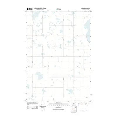
2012 Map of Waubay SW
USGS Topo · Published 2012About this map
Glacial lakes and marshy sloughs define the landscape of Day County in this 2012 survey. The region is dominated by significant water bodies, including the southern reaches of South Waubay Lake at the northern border and the expansive Rush Lake to the east. The terrain is structured by a rigid grid of section-line roads such as 437th Ave and 143rd St, which intersect the path of US Route 12 as it crosses through the center of the sheet. Genealogical and local history points of interest are preserved at Salem Cem and Old Saint Otto's Cem. Between these landmarks, Antelope Lake and Solomon Slough illustrate the characteristic prairie pothole topography that shapes the agricultural and drainage patterns of the area.
Find a feature on this map
23 named features on this map. Tap any name to fly to it.
Don’t see what you’re looking for? This feature index may not catch every label — zoom into the map to look around manually.
Map Details
Editions of this 2012 Waubay SW Map
This is the sole edition of this map. No revisions or reprints were ever made.
Other maps of this area

1953 · Milbank
USGS Topo · 1:250,000

1958 · Milbank
USGS Topo · 1:250,000

1970 · Waubay
USGS Topo · 1:24,000

1970 · Florence NE
USGS Topo · 1:24,000

1970 · Waubay SW
USGS Topo · 1:24,000

1970 · Roslyn
USGS Topo · 1:24,000

1970 · Enemy Swim Lake West
USGS Topo · 1:24,000

1973 · Webster
USGS Topo · 1:24,000

1973 · Swan Lake
USGS Topo · 1:24,000
1973 · Webster NE
USGS Topo · 1:24,000