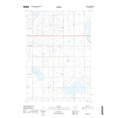
2017 Map of Waubay SW
USGS Topo · Published 2017About this map
The Coteau des Prairies plateau defines this corner of Day County, creating a glaciated landscape characterized by numerous basins and permanent water bodies. Large lake systems dominate the periphery, including South Waubay Lake to the north and the expansive Bitter Lake in the southeast. This environment shaped the early rural settlement of the region, visible through the placement of community institutions along the section-line roads. Genealogists can identify several distinct burial grounds and parishes that served the local farming population, such as Zoar Lutheran Church and its associated Zoar Lutheran Rusk Cem, alongside the Old Saint Otto's Church and Old Saint Otto's Cem. The map provides a clear record of the rural infrastructure, from the drainage of Solomon Slough to the established grid of county roads like Co RD 20 and Co RD 28.
Find a feature on this map
25 named features on this map. Tap any name to fly to it.
Don’t see what you’re looking for? This feature index may not catch every label — zoom into the map to look around manually.
Map Details
Editions of this 2017 Waubay SW Map
This is the sole edition of this map. No revisions or reprints were ever made.
Other maps of this area

1953 · Milbank
USGS Topo · 1:250,000

1958 · Milbank
USGS Topo · 1:250,000

1970 · Waubay
USGS Topo · 1:24,000

1970 · Florence NE
USGS Topo · 1:24,000

1970 · Waubay SW
USGS Topo · 1:24,000

1970 · Roslyn
USGS Topo · 1:24,000

1970 · Enemy Swim Lake West
USGS Topo · 1:24,000

1973 · Webster
USGS Topo · 1:24,000

1973 · Swan Lake
USGS Topo · 1:24,000
1973 · Webster NE
USGS Topo · 1:24,000