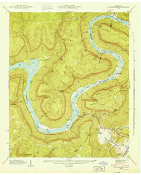
1943 Map of Wauhatchie
USGS Topo · Published 1943About this map
The Tennessee River creates a massive, serpentine loop around Raccoon Mountain, defining the rugged topography of this river-and-ridge landscape in the early 1940s. The waterway is dominated by the Hales Bar Reservoir, which flooded several historic river hazards known locally as The Suck, The Pot, and The Pan. The presence of Kellys Ferry and the Lee Highway indicate the primary transportation corridors through this difficult terrain, while family-named landmarks like Alex McNabb Hicks Gap and Massengale Pt suggest deep ancestral ties to the land.
Find a feature on this map
84 named features on this map. Tap any name to fly to it.
Don’t see what you’re looking for? This feature index may not catch every label — zoom into the map to look around manually.
Map Details
Editions of this 1943 Wauhatchie Map
This is the sole edition of this map. No revisions or reprints were ever made.
Other maps of this area

1886 · Ringgold
USGS Topo · 1:125,000

1886 · Stevenson
USGS Topo · 1:125,000

1888 · Chattanooga
USGS Topo · 1:125,000

1892 · Ringgold
USGS Topo · 1:125,000

1892 · Stevenson
USGS Topo · 1:125,000

1893 · Chattanooga
USGS Topo · 1:125,000

1895 · Stevenson
USGS Topo · 1:125,000

1895 · Sewanee
USGS Topo · 1:125,000

1936 · Shellmound
USGS Topo · 1:24,000

1936 · Whitwell
USGS Topo · 1:24,000