
1963 Map of Wausau
USGS Topo · Published 1965About this map
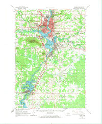
The Wisconsin River corridor serves as the industrial and social spine of this 1963 survey, anchoring the primary urban centers of Wausau, Schofield, and Rothschild. The river's influence is evident in the sprawling Mosinee Flowage and the intricate wetlands of Black Swamp. Dominating the western horizon is the massive profile of Rib Mountain, home to Rib Mountain State Park, which stands in contrast to the dense residential grids of the river valley. To the south, the city of Mosinee is depicted with its local landmarks like the Mosinee Lookout Tower and the oddly named Cemetery Slough.
Find a feature on this map
74 named features on this map. Tap any name to fly to it.
Don’t see what you’re looking for? This feature index may not catch every label — zoom into the map to look around manually.
Map Details
Editions of this 1963 Wausau Map
2 editions found
Other maps of this area

1899 · Wausau
USGS Topo · 1:125,000

1902 · Wausau
USGS Topo · 1:125,000

1902 · Marathon
USGS Topo · 1:125,000

1951 · Doering
USGS Topo · 1:48,000

1951 · Merrill
USGS Topo · 1:48,000

1951 · Hamburg
USGS Topo · 1:48,000

1953 · Wausau
USGS Topo · 1:48,000

1953 · Marathon
USGS Topo · 1:48,000

1953 · Hatley
USGS Topo · 1:48,000

1954 · Iron Mountain
USGS Topo · 1:250,000