
Loading...
Loading map...1984 Map of Wausau
USGS Topo · Published 1990About this map
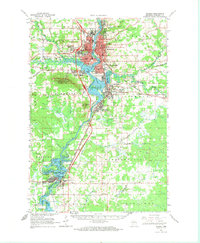
Rib Mountain dominates the central landscape of this Marathon County region, standing as a prominent landmark above the Wisconsin River valley. The river serves as the primary corridor for settlement and industry, connecting Wausau, Schofield, Rothschild, and Mosinee. The mid-1980s infrastructure is well-defined, showing the paths of the Chicago and North Western and Soo Line railroads alongside major routes like U S 51.
Find a feature on this map
201 named features on this map. Tap any name to fly to it.
Don’t see what you’re looking for? This feature index may not catch every label — zoom into the map to look around manually.
Map Details
Date Portrayed1984
Date Published1990
PublisherU.S. Geological Survey
Map TypeTopographic
Scale1:100,000
Physical Dimensions37.96 x 24.13 inches
Editions of this 1984 Wausau Map
This is the sole edition of this map. No revisions or reprints were ever made.
Historical Maps of Wausau Through Time
5 maps found


Featured Locations
Source Details
SourceU.S. Geological Survey
CopyrightPublic Domain