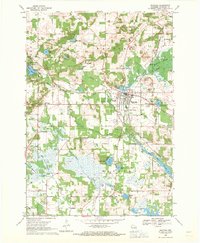
1968 Map of Wautoma
USGS Topo · Published 1971About this map
The city of Wautoma serves as the focal point of this Central Wisconsin landscape, where the Chicago and North Western railroad cuts a diagonal path through the glacial terrain. In the late 1960s, the area's development is marked by a mix of civic infrastructure and rural industry, including the Fairground, a Drive-in Theater near Bughs Lake, and the Wautoma Airport situated south of town. The hydrography is particularly intricate, dominated by the White River Flowage and a series of spring-fed basins like Witters Lake and Meilke Lake. Genealogists will find a high density of burial sites throughout the townships of Dakota and Wautoma, ranging from the North Dakota Cemetery to the Raymond Cemetery in the southeastern corner, reflecting the deep-rooted settlement patterns of Waushara County.
Find a feature on this map
53 named features on this map. Tap any name to fly to it.
Don’t see what you’re looking for? This feature index may not catch every label — zoom into the map to look around manually.
Map Details
Editions of this 1968 Wautoma Map
This is the sole edition of this map. No revisions or reprints were ever made.
Other maps of this area

1915 · Neshkoro
USGS Topo · 1:48,000

1918 · Neshkoro
USGS Topo · 1:62,500

1955 · Green Bay
USGS Topo · 1:250,000

1957 · Madison
USGS Topo · 1:250,000

1959 · Wautoma
USGS Topo · 1:48,000

1960 · Madison
USGS Topo · 1:250,000

1961 · Redgranite
USGS Topo · 1:62,500

1961 · Montello
USGS Topo · 1:62,500

1961 · Wild Rose
USGS Topo · 1:24,000

1961 · Spring Lake
USGS Topo · 1:24,000