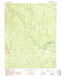
1992 Map of Wawona
USGS Topo · Published 1995About this map
Wawona serves as a central hub within this high-elevation landscape, where the South Fork Merced River carves through the transition between the Sierra National Forest and Yosemite National Park. The map reveals a community focused on recreation and preservation, featuring the Golf Course, the Wawona Sewage Disposal Plant, and the local Wawona Sch. Historical transit and infrastructure are represented by the Wawona Road and a notable Covered Bridge crossing the river. To the south and west, the Chowchilla Mountains and Turner Ridge define the steep drainage basins of Elevenmile Creek and Chilnualna Creek. Several remote sites, such as Stovepipe Campground, Summit Campground, and the high-altitude Empire Meadows, underscore the area's role as a gateway to the Yosemite Wilderness. Landmarks like Mount Savage and Devil Peak provide fixed points for navigating the terrain before it reaches the park's deeper interior.
Find a feature on this map
35 named features on this map. Tap any name to fly to it.
Don’t see what you’re looking for? This feature index may not catch every label — zoom into the map to look around manually.
Map Details
Editions of this 1992 Wawona Map
This is the sole edition of this map. No revisions or reprints were ever made.
Other maps of this area

1897 · Yosemite
USGS Topo · 1:125,000

1900 · Yosemite
USGS Topo · 1:125,000

1903 · Yosemite
USGS Topo · 1:125,000

1909 · Yosemite
USGS Topo · 1:125,000

1912 · Mariposa
USGS Topo · 1:125,000

1947 · El Portal
USGS Topo · 1:24,000

1947 · Mariposa
USGS Topo · 1:250,000

1947 · El Portal
USGS Topo · 1:62,500

1947 · Mariposa
USGS Topo · 1:62,500

1947 · Buckingham Mtn
USGS Topo · 1:24,000