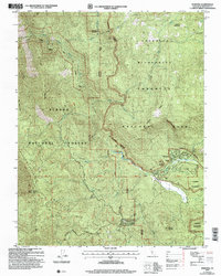
2004 Map of Wawona
USGS Topo · Published 2007About this map
Wawona serves as a central hub on this 2004 revision, situated along the South Fork Merced Wild and Scenic River. This portion of the Yosemite National Park and Sierra National Forest boundary illustrates the infrastructure required to support mountain residency and tourism, from the Wawona School and a Golf Course to the functional Sewage Disposal Plant and Water Tanks. The historic Covered Bridge remains a focal point of the settlement's character near the Gaging Station.
Find a feature on this map
35 named features on this map. Tap any name to fly to it.
Don’t see what you’re looking for? This feature index may not catch every label — zoom into the map to look around manually.
Map Details
Editions of this 2004 Wawona Map
This is the sole edition of this map. No revisions or reprints were ever made.
Other maps of this area

1897 · Yosemite
USGS Topo · 1:125,000

1900 · Yosemite
USGS Topo · 1:125,000

1903 · Yosemite
USGS Topo · 1:125,000

1909 · Yosemite
USGS Topo · 1:125,000

1912 · Mariposa
USGS Topo · 1:125,000

1947 · El Portal
USGS Topo · 1:24,000

1947 · Mariposa
USGS Topo · 1:250,000

1947 · El Portal
USGS Topo · 1:62,500

1947 · Mariposa
USGS Topo · 1:62,500

1947 · Buckingham Mtn
USGS Topo · 1:24,000