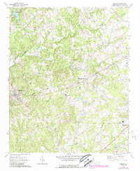
1970 Map of Waxhaw
USGS Topo · Published 1988About this map
The Seaboard Coast Line railroad cuts a straight diagonal through this Union County landscape, anchoring the development of Waxhaw and Mineral Springs. This 1970s era documentation, updated with late-1980s data, reveals a rural network of churches and cemeteries that speak to the region's deep social history, including Smyrna Ch, Howie Ch, and Thompson Chapel. The terrain is defined by the branching tributaries of Twelvemile Creek, where numerous family-named landmarks like Walker Cem and McWhorter Cem are preserved. Small rural clusters like Roughedge and Houston appear alongside evolving infrastructure, such as the Landing Strip near Weddington and the Western Union Sch, illustrating the transition from traditional farming communities to a more modern infrastructure footprint.
Find a feature on this map
44 named features on this map. Tap any name to fly to it.
Don’t see what you’re looking for? This feature index may not catch every label — zoom into the map to look around manually.
Map Details
Editions of this 1970 Waxhaw Map
3 editions found
Other maps of this area

1905 · Charlotte
USGS Topo · 1:48,000

1907 · Charlotte
USGS Topo · 1:62,500

1941 · Charlotte
USGS Topo · 1:125,000

1941 · Spartanburg
USGS Topo · 1:250,000

1942 · Charlotte
USGS Topo · 1:125,000

1953 · Spartanburg
USGS Topo · 1:250,000

1953 · Charlotte
USGS Topo · 1:250,000

1954 · Charlotte
USGS Topo · 1:250,000

1960 · Charlotte
USGS Topo · 1:250,000

1960 · Spartanburg
USGS Topo · 1:250,000