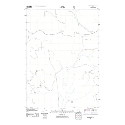
2011 Map of Wayan East
USGS Topo · Published 2011About this map
Middle Dairy and Upper Dairy are central landmarks in this high-elevation pastoral landscape of Caribou County, where a complex network of waterways defines the terrain. The drainage of Lanes Creek and Tincup Creek dominates the hydrology, supported by numerous smaller tributaries such as Chippy Creek, Olsen Creek, and Daves Creek. This 2011 survey reflects the area’s continued reliance on forestry and ranching infrastructure, as seen in the naming of cattle-related sites and a system of Forest Service roads including Caribou NF RD 190 and Caribou NF RD 117. Distinctive features like Midnight Spring and the rugged Browns Canyon indicate a remote environment where natural water sources and topographical breaks are key markers for navigation and land use in the southeast Idaho mountains.
Find a feature on this map
24 named features on this map. Tap any name to fly to it.
Don’t see what you’re looking for? This feature index may not catch every label — zoom into the map to look around manually.
Map Details
Editions of this 2011 Wayan East Map
This is the sole edition of this map. No revisions or reprints were ever made.
Other maps of this area

1915 · Freedom
USGS Topo · 1:62,500

1915 · Lanes Creek
USGS Topo · 1:62,500

1932 · Irwin
USGS Topo · 1:96,000

1935 · Irwin
USGS Topo · 1:125,000

1949 · Lower Valley
USGS Topo · 1:24,000

1951 · Lower Valley
USGS Topo · 1:24,000
1951 · Upper Valley
USGS Topo · 1:24,000

1955 · Driggs
USGS Topo · 1:250,000

1955 · Preston
USGS Topo · 1:250,000

1958 · Driggs
USGS Topo · 1:250,000