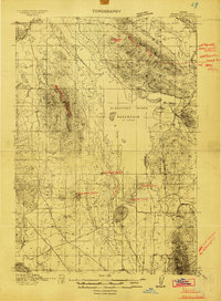
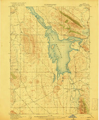
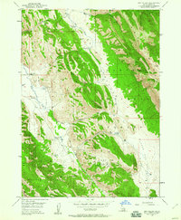
1949 Map of Lower Valley
USGS Topo · Published 1971About this map
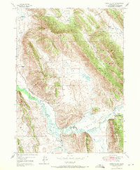
Enoch Valley and the neighboring Woolley Valley define the settlement pattern of this Idaho landscape at the end of the 1940s. The map illustrates a high-altitude agricultural economy through several named family properties, including Stocking Ranch, Fox Ranch, and W Steadman Ranch. These holdings are positioned near the serpentine course of the Blackfoot River and its various tributaries like Slug Creek and Angus Creek. The northeastern portion of the sheet is dominated by the Caribou National Forest, where the topography rises sharply along Rasmussen Ridge. Traces of early industrial activity appear as scattered Prospects and a Gravel Pit, while a system of canals and a Ditch network suggest a reliance on managed water for ranching. This document captures the remote character of Caribou County before modern developments, showing the essential Trail and road links like Valley Road that connected these isolated homesteads.
Find a feature on this map
24 named features on this map. Tap any name to fly to it.
Don’t see what you’re looking for? This feature index may not catch every label — zoom into the map to look around manually.
Map Details
Editions of this 1949 Lower Valley Map
3 editions found
Other maps of this area

1911 · Slug Creek
USGS Topo · 1:62,500
1914 · Henry
USGS Topo · 1:48,000

1915 · Lanes Creek
USGS Topo · 1:62,500
1916 · Henry
USGS Topo · 1:62,500
1948 · Soda Springs
USGS Topo · 1:62,500
1949 · Soda Springs
USGS Topo · 1:62,500
1949 · Johnson Creek
USGS Topo · 1:24,000
1949 · Dry Valley
USGS Topo · 1:24,000
1951 · Lower Valley
USGS Topo · 1:24,000
1951 · Upper Valley
USGS Topo · 1:24,000