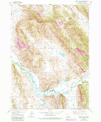
1949 Map of Lower Valley
USGS Topo · Published 1984About this map
The Caribou Range and the winding Blackfoot River dominate this Idaho landscape, where high-altitude ranching and mineral exploration define the terrain. Established family holdings including the Stocking Ranch, Fox Ranch, and Allen Ranch are distributed along the valley floors, linked by the Blackfoot River Road. This 1949 survey illustrates the early industrial footprint in the Caribou National Forest, featuring the Blackfoot River Railroad and several Prospects scattered across the ridges. The complex drainage of the Lower Blackfoot Valley is captured here in detail, showing how Slug Creek and Dry Valley Cr feed into the river system. This map is an essential resource for tracing the mid-century agricultural and industrial development of the Enoch Valley and Wooley Valley regions.
Find a feature on this map
25 named features on this map. Tap any name to fly to it.
Don’t see what you’re looking for? This feature index may not catch every label — zoom into the map to look around manually.
Map Details
Editions of this 1949 Lower Valley Map
3 editions found
Other maps of this area

1911 · Slug Creek
USGS Topo · 1:62,500

1914 · Henry
USGS Topo · 1:48,000

1915 · Lanes Creek
USGS Topo · 1:62,500

1916 · Henry
USGS Topo · 1:62,500

1948 · Soda Springs
USGS Topo · 1:62,500

1949 · Soda Springs
USGS Topo · 1:62,500

1949 · Johnson Creek
USGS Topo · 1:24,000

1949 · Dry Valley
USGS Topo · 1:24,000

1949 · Lower Valley
USGS Topo · 1:24,000

1951 · Lower Valley
USGS Topo · 1:24,000