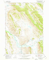
1949 Map of Lower Valley
USGS Topo · Published 1977About this map
Caribou National Forest dominates the high ground of this Idaho landscape, where the eastern slopes descend into the broad basins of Enoch Valley and Woolley Valley. The drainage of the Blackfoot River carves a winding path across the terrain, supplemented by an extensive network of human-made water infrastructure including a Ditch system and multiple Weir locations. This 1949 topographic survey illustrates a rural economy centered on established family holdings, marking several homesteads such as W Steadman Ranch, Fox Ranch, and the Stocking Ranch. Movement through the area is defined by the north-south orientations of the Rasmussen Ridge and the Aspen Range, while smaller landmarks like Grain Tanks and localized Prospects indicate the specific agricultural and mineral interests of the mid-century period.
Find a feature on this map
29 named features on this map. Tap any name to fly to it.
Don’t see what you’re looking for? This feature index may not catch every label — zoom into the map to look around manually.
Map Details
Editions of this 1949 Lower Valley Map
3 editions found
Other maps of this area

1911 · Slug Creek
USGS Topo · 1:62,500

1914 · Henry
USGS Topo · 1:48,000

1915 · Lanes Creek
USGS Topo · 1:62,500

1916 · Henry
USGS Topo · 1:62,500

1948 · Soda Springs
USGS Topo · 1:62,500

1949 · Soda Springs
USGS Topo · 1:62,500

1949 · Johnson Creek
USGS Topo · 1:24,000

1949 · Dry Valley
USGS Topo · 1:24,000

1949 · Lower Valley
USGS Topo · 1:24,000

1951 · Lower Valley
USGS Topo · 1:24,000