
1951 Map of Lower Valley
USGS Topo · Published 1951About this map
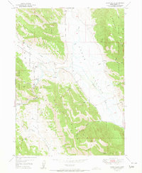
The Blackfoot River winds through this Idaho landscape, carving a path between the Wooley Range and the prominent Schmid Ridge. This mid-century survey illustrates a ranching-heavy corridor, where family holdings such as the Stocking Ranch, Fox Ranch, and W Steadman Ranch define the land use patterns along the valley floor. The influence of the Caribou National Forest is evident across the eastern ridges, while numerous scattered Springs provide critical water sources for the livestock operations in Enoch Valley and Lower Valley. Cultural landmarks include several benchmarks like BM 6340 and Grain Tanks near the Allen Ranch, marking the infrastructure of this high-elevation agricultural community. The map also records early extractive activity with labels for a Gravel Pit and several Prospects near the southern bend of the river.
Find a feature on this map
36 named features on this map. Tap any name to fly to it.
Don’t see what you’re looking for? This feature index may not catch every label — zoom into the map to look around manually.
Map Details
Editions of this 1951 Lower Valley Map
This is the sole edition of this map. No revisions or reprints were ever made.
Other maps of this area

1911 · Slug Creek
USGS Topo · 1:62,500

1914 · Henry
USGS Topo · 1:48,000

1915 · Lanes Creek
USGS Topo · 1:62,500

1916 · Henry
USGS Topo · 1:62,500

1948 · Soda Springs
USGS Topo · 1:62,500

1949 · Soda Springs
USGS Topo · 1:62,500

1949 · Johnson Creek
USGS Topo · 1:24,000

1949 · Dry Valley
USGS Topo · 1:24,000

1949 · Lower Valley
USGS Topo · 1:24,000
1951 · Upper Valley
USGS Topo · 1:24,000