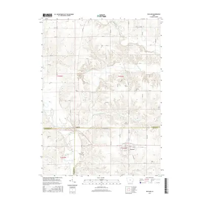
2015 Map of Wayland
USGS Topo · Published 2015About this map
Wayland stands as the primary settlement on this 2015 survey, situated in the southeast quadrant where N Pearl St and E Main St form the town's core. The landscape is defined by the winding course of the Skunk River in the southwest, while Crooked Creek and the West Fork Crooked Creek carve through the north and east. The map reveals a dense distribution of rural burial sites, including the Wayland Cem, Eicher Cem, and Pleasant Hill Cem, reflecting the deep-rooted family history of this agricultural region. The border town of Coppock sits at the junction of Henry-Washington St, marking the divide between Henry, Washington, and Jefferson counties. This intersection of river valleys and surveyed section roads illustrates the transition from river-bottom land to the upland prairies of southeastern Iowa.
Find a feature on this map
64 named features on this map. Tap any name to fly to it.
Don’t see what you’re looking for? This feature index may not catch every label — zoom into the map to look around manually.
Map Details
Editions of this 2015 Wayland Map
This is the sole edition of this map. No revisions or reprints were ever made.
Other maps of this area

1958 · Davenport
USGS Topo · 1:250,000

1961 · Davenport
USGS Topo · 1:250,000

1962 · Davenport
USGS Topo · 1:250,000

1969 · Washington
USGS Topo · 1:24,000

1970 · Ainsworth
USGS Topo · 1:24,000

1973 · West Chester
USGS Topo · 1:24,000

1980 · Brighton
USGS Topo · 1:24,000

1980 · Trenton
USGS Topo · 1:24,000

1980 · Wayland
USGS Topo · 1:24,000
1980 · Salina
USGS Topo · 1:24,000