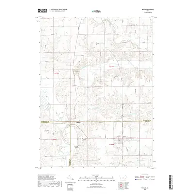
2018 Map of Wayland
USGS Topo · Published 2018About this map
Wayland and Coppock serve as the primary anchors in this rural landscape where the borders of Washington, Henry, and Jefferson counties converge. The terrain is defined by the winding course of the Skunk River in the southwest and the branching reach of Crooked Creek and Williams Creek through the central and northern sections. For genealogists and local historians, this map is particularly valuable for its high density of family and community burial sites, including Shiloh Cem, Bethel Cem, and Pleasant Hill Cem. The settlement pattern follows a grid of county roads such as Sockum Ridge Rd, while the town of Wayland shows a concentrated residential core along E Main St and W Front St. This survey captures the enduring agricultural character of southeast Iowa, preserving the locations of numerous historic landmarks like Armstrong Cem and Sugar Creek Cem within the larger watershed of the West Fork Crooked Creek.
Find a feature on this map
51 named features on this map. Tap any name to fly to it.
Don’t see what you’re looking for? This feature index may not catch every label — zoom into the map to look around manually.
Map Details
Editions of this 2018 Wayland Map
This is the sole edition of this map. No revisions or reprints were ever made.
Other maps of this area

1958 · Davenport
USGS Topo · 1:250,000

1961 · Davenport
USGS Topo · 1:250,000

1962 · Davenport
USGS Topo · 1:250,000

1969 · Washington
USGS Topo · 1:24,000

1970 · Ainsworth
USGS Topo · 1:24,000

1973 · West Chester
USGS Topo · 1:24,000

1980 · Brighton
USGS Topo · 1:24,000

1980 · Trenton
USGS Topo · 1:24,000

1980 · Wayland
USGS Topo · 1:24,000
1980 · Salina
USGS Topo · 1:24,000