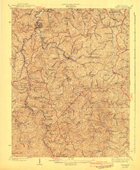
1941 Map of Wayne
USGS Topo · Published 1941About this map
Twelvepole Creek winds through this West Virginia landscape, providing the primary drainage for a deeply dissected network of ridges and hollows during the early 1940s. The settlement at Wayne serves as a focal point along the Norfolk and Western RR, while further south, smaller communities like East Lynn and Radnor are linked by the winding rail line and local creek branches. The map reveals a dense rural infrastructure of family and community life, marked by an exceptional number of small schools such as Marshall Sch and Mt Union Sch, and the presence of local religious centers like Bethesda Ch. The terrain is defined by prominent elevations including Wheeler Knob and Turkeycamp Knob, which dictated the early road patterns following the water gaps. This era represents a time when the rural education system was still highly decentralized, as evidenced by the numerous named schoolhouses serving isolated hollows like Likens Ridge Sch and Wolfpen Sch.
Find a feature on this map
99 named features on this map. Tap any name to fly to it.
Don’t see what you’re looking for? This feature index may not catch every label — zoom into the map to look around manually.
Map Details
Editions of this 1941 Wayne Map
This is the sole edition of this map. No revisions or reprints were ever made.
Other maps of this area

1886 · Prestonsburg
USGS Topo · 1:125,000

1887 · Warfield
USGS Topo · 1:125,000

1891 · Warfield
USGS Topo · 1:125,000

1892 · Prestonsburg
USGS Topo · 1:125,000

1892 · Huntington
USGS Topo · 1:125,000

1898 · Huntington
USGS Topo · 1:125,000

1901 · Guyandot
USGS Topo · 1:62,500

1901 · Ceredo
USGS Topo · 1:62,500

1902 · Guyandot
USGS Topo · 1:62,500

1902 · Milton
USGS Topo · 1:62,500