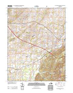
2013 Map of Waynesboro West
USGS Topo · Published 2013About this map
Fishersville and the surrounding residential developments west of Waynesboro define this landscape, illustrating the suburban expansion along the Interstate 64 corridor. The map records a dense network of neighborhoods including Teaverton, Emerald Hills, and Westover Hills, which sit in contrast to the more industrial or rural south. The S River winds through the central valley, connecting the established community of Lyndhurst with Lipscomb. Aviation history is noted by the presence of Eagle's Nest Airport, while the hydrology of the Shenandoah Valley is visible through features like Tinkling Spring, Coiner Spring, and the Baker Springs Basin. Higher elevations are marked by landmarks such as Miller Knob and the start of the Blue Ridge rise at Afton Mountain and Elk Mountain.
Find a feature on this map
272 named features on this map. Tap any name to fly to it.
Don’t see what you’re looking for? This feature index may not catch every label — zoom into the map to look around manually.
Map Details
Editions of this 2013 Waynesboro West Map
This is the sole edition of this map. No revisions or reprints were ever made.
Other maps of this area

1892 · Buckingham
USGS Topo · 1:125,000

1892 · Harrisonburg
USGS Topo · 1:125,000

1894 · Staunton
USGS Topo · 1:125,000

1894 · Lexington
USGS Topo · 1:125,000

1934 · Waynesboro
USGS Topo · 1:48,000

1936 · Vesuvius
USGS Topo · 1:48,000

1939 · Waynesboro
USGS Topo · 1:62,500

1941 · Vesuvius
USGS Topo · 1:62,500

1943 · Lovingston
USGS Topo · 1:62,500

1944 · Staunton
USGS Topo · 1:62,500