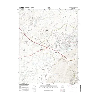
2016 Map of Waynesboro West
USGS Topo · Published 2016About this map
Waynesboro and the expanding suburbs of Augusta County are shown here during a period of significant growth along the South River corridor. The map documents the development patterns connecting the historic center of Waynesboro with surrounding communities like Fishersville, Ladd, and Stuarts Draft. Long-standing landmarks such as the Tinkling Spring church and nearby Augusta Memorial Gardens sit alongside mid-century residential clusters at Westover Hills and Kingsbury Manor. To the south, the terrain rises sharply into the George Washington National Forest, where the landscape shifts from valley floor agriculture and industry to the steep ridges of Afton Mtn and Stony Ridge. This 2016 survey captures the transition from the industrial heritage of the Baker Springs Basin area to the preserved wilderness of the Blue Ridge Parkway corridor, providing a clear record of local infrastructure, including Eagle's Nest Airport and the complex road network branching from Woodrow Wilson Ave.
Find a feature on this map
236 named features on this map. Tap any name to fly to it.
Don’t see what you’re looking for? This feature index may not catch every label — zoom into the map to look around manually.
Map Details
Editions of this 2016 Waynesboro West Map
This is the sole edition of this map. No revisions or reprints were ever made.
Other maps of this area

1892 · Buckingham
USGS Topo · 1:125,000

1892 · Harrisonburg
USGS Topo · 1:125,000

1894 · Staunton
USGS Topo · 1:125,000

1894 · Lexington
USGS Topo · 1:125,000

1934 · Waynesboro
USGS Topo · 1:48,000

1936 · Vesuvius
USGS Topo · 1:48,000

1939 · Waynesboro
USGS Topo · 1:62,500

1941 · Vesuvius
USGS Topo · 1:62,500

1943 · Lovingston
USGS Topo · 1:62,500

1944 · Staunton
USGS Topo · 1:62,500