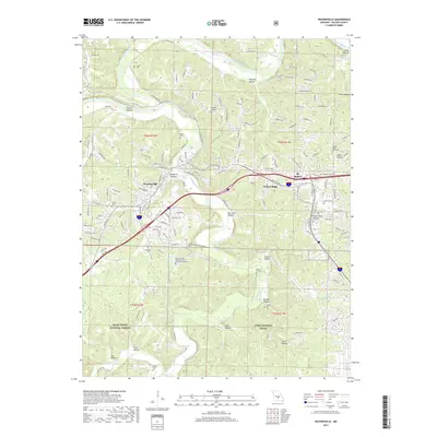
2017 Map of Waynesville
USGS Topo · Published 2017About this map
Waynesville and St. Robert anchor this modern topographic view of the Ozark Plateau, where the winding Gasconade River and its tributaries carve a complex landscape of hollows and ridges. The map illustrates the significant intersection of civilian and military life, dominated by the northern extent of Fort Leonard Wood and the Missouri State Veterans Cem Fort Leonard Wood. Natural features like Roubidoux Spring and Cole Spring highlight the region's karst topography, while the dense network of rural roads such as Old Rte 66 and State Hwy Y shows how the communities have grown around key transport corridors. Family history is well-preserved through numerous small burial grounds, including the Turpin Cem, Laughlin Cem, and Cedar Hill Cem, which sit alongside the vast Mark Twain National Forest.
Find a feature on this map
141 named features on this map. Tap any name to fly to it.
Don’t see what you’re looking for? This feature index may not catch every label — zoom into the map to look around manually.
Map Details
Editions of this 2017 Waynesville Map
This is the sole edition of this map. No revisions or reprints were ever made.
Other maps of this area

1936 · Waynesville
USGS Topo · 1:48,000

1941 · Big Piney
USGS Topo · 1:62,500

1942 · Waynesville
USGS Topo · 1:62,500

1943 · Richland
USGS Topo · 1:62,500

1943 · Big Piney
USGS Topo · 1:62,500

1943 · Drynob
USGS Topo · 1:62,500

1944 · Waynesville
USGS Topo · 1:62,500

1954 · Springfield
USGS Topo · 1:250,000
1954 · Hancock
USGS Topo · 1:24,000

1954 · Drynob
USGS Topo · 1:62,500