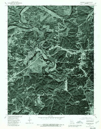
1976 Map of Waynesville
USGS Topo · Published 1980About this map
Waynesville and St Robert sit at the center of this 1976 orthophoto map, illustrating the post-war growth of these Missouri communities along the corridor leading to the northern edge of Fort Leonard Wood. The aerial imagery reveals a sharp contrast between the dense woodlands of the Ozarks and the expanding footprints of residential and commercial development near the highway. The winding course of the Gasconade River dominates the northern portion of the quadrangle, while Roubidoux Creek meanders through the heart of the landscape, defining the valley where the primary settlements established themselves. This specific document provides an uncommon visual perspective by layering property lines and geographical boundaries directly over a high-resolution aerial photograph, allowing researchers to see exactly how the land was being utilized and occupied during the mid-1970s.
Find a feature on this map
5 named features on this map. Tap any name to fly to it.
Don’t see what you’re looking for? This feature index may not catch every label — zoom into the map to look around manually.
Map Details
Editions of this 1976 Waynesville Map
This is the sole edition of this map. No revisions or reprints were ever made.
Other maps of this area

1936 · Waynesville
USGS Topo · 1:48,000

1941 · Big Piney
USGS Topo · 1:62,500

1942 · Waynesville
USGS Topo · 1:62,500

1943 · Richland
USGS Topo · 1:62,500

1943 · Big Piney
USGS Topo · 1:62,500

1943 · Drynob
USGS Topo · 1:62,500

1944 · Waynesville
USGS Topo · 1:62,500

1954 · Springfield
USGS Topo · 1:250,000
1954 · Hancock
USGS Topo · 1:24,000

1954 · Drynob
USGS Topo · 1:62,500