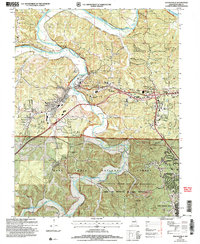
2004 Map of Waynesville
USGS Topo · Published 2006About this map
Roubidoux Creek winds through this Ozark landscape, meeting the Gasconade River near the northern boundary of the Fort Leonard Wood Military Reservation. The town of Waynesville serves as a central hub, where the historic path of Route 66 intersects with modern infrastructure near the Waynesville General Hospital and Memorial Park Cem. North of the military boundary, the terrain is defined by numerous hollows like Trower Hollow and Pippin Hollow, while landmarks like the Drive-in Theater and Roubidoux Spring point to the area's mid-century development.
Find a feature on this map
51 named features on this map. Tap any name to fly to it.
Don’t see what you’re looking for? This feature index may not catch every label — zoom into the map to look around manually.
Map Details
Editions of this 2004 Waynesville Map
This is the sole edition of this map. No revisions or reprints were ever made.
Other maps of this area

1936 · Waynesville
USGS Topo · 1:48,000

1941 · Big Piney
USGS Topo · 1:62,500

1942 · Waynesville
USGS Topo · 1:62,500

1943 · Richland
USGS Topo · 1:62,500

1943 · Big Piney
USGS Topo · 1:62,500

1943 · Drynob
USGS Topo · 1:62,500

1944 · Waynesville
USGS Topo · 1:62,500

1954 · Springfield
USGS Topo · 1:250,000
1954 · Hancock
USGS Topo · 1:24,000

1954 · Drynob
USGS Topo · 1:62,500