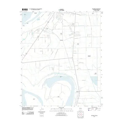
2011 Map of Wayside
USGS Topo · Published 2011About this map
Swiftwater and Wayside anchor this landscape along the eastern bank of the Mississippi River south of Greenville. The terrain is defined by the complex water engineering of the Delta, featuring a dense network of drainage projects including Ditch Number Five and Main Canal. Evidence of the region's dynamic river history is visible in features like the La Grange Crevasse and the Leland Cutoff, where the river has carved and reshaped the land over time. The map also documents modern agricultural and local infrastructure, from the L and W Catfish Ponds Dam to family-named landmarks like the James and Bobby Dycus Pond Dam. Between the small settlements, large tracts are dedicated to aviation and community spaces, including the Fairfield Airport and the Lakeview Gardens Cemetery.
Find a feature on this map
86 named features on this map. Tap any name to fly to it.
Don’t see what you’re looking for? This feature index may not catch every label — zoom into the map to look around manually.
Map Details
Editions of this 2011 Wayside Map
This is the sole edition of this map. No revisions or reprints were ever made.
Other maps of this area

1939 · Readland
USGS Topo · 1:62,500

1939 · Refuge
USGS Topo · 1:62,500

1939 · Tralake
USGS Topo · 1:62,500

1939 · Swan Lake
USGS Topo · 1:62,500

1953 · Greenwood
USGS Topo · 1:250,000

1956 · Greenwood
USGS Topo · 1:250,000

1967 · Arcola
USGS Topo · 1:24,000

1967 · Leland
USGS Topo · 1:24,000
1967 · Swan Lake NW
USGS Topo · 1:24,000
1969 · Swan Lake
USGS Topo · 1:62,500