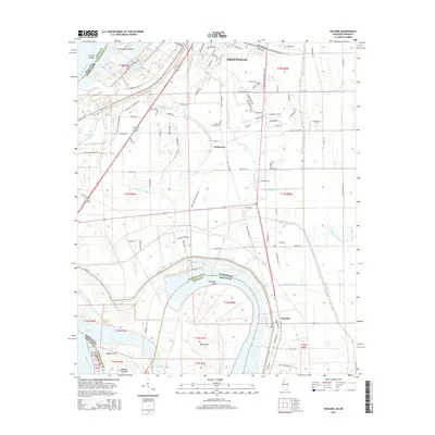
2015 Map of Wayside
USGS Topo · Published 2015About this map
Greenville serves as the focal point for this landscape, where the urban street grid of Washington County transitions into the fertile alluvial plains of the Delta. The southern edge of the city gives way to smaller settlements like Swiftwater and Wayside, following the curve of the Mississippi River. This reach of the river is defined by complex hydrological features, including the massive American Bend and the Leland Cutoff, which illustrate the historical engineering required to manage the river's path. Low-lying areas are marked by several towheads and islands, such as Bell Island and the La Grange Towhead. The land is heavily intersected by a systematic drainage network including Main Canal and various numbered ditches like Ditch Number Seven, supporting the region's agricultural character. Local history is anchored by sites like the Lakeview Gardens Cem and landmarks like the La Grange Crevasse, a name that recalls the river's power to breach its banks.
Find a feature on this map
108 named features on this map. Tap any name to fly to it.
Don’t see what you’re looking for? This feature index may not catch every label — zoom into the map to look around manually.
Map Details
Editions of this 2015 Wayside Map
This is the sole edition of this map. No revisions or reprints were ever made.
Other maps of this area

1939 · Readland
USGS Topo · 1:62,500

1939 · Refuge
USGS Topo · 1:62,500

1939 · Tralake
USGS Topo · 1:62,500

1939 · Swan Lake
USGS Topo · 1:62,500

1953 · Greenwood
USGS Topo · 1:250,000

1956 · Greenwood
USGS Topo · 1:250,000

1967 · Arcola
USGS Topo · 1:24,000

1967 · Leland
USGS Topo · 1:24,000
1967 · Swan Lake NW
USGS Topo · 1:24,000
1969 · Swan Lake
USGS Topo · 1:62,500